
HISTORIC FORT SNELLING AT BDOTE REVITALIZATION
Dakota elders tell of the creation of humans occurring in our homeland of Mni Sota Makoce (Land Where the Waters Reflect the Clouds), but specifically at the place called Maka Cokaya Kin, or the Center of the Earth. This place is at Bdote, which means the joining or juncture of two bodies of water and in this instance refers to the area where the Minnesota River joins the Mississippi River. The Dakota have ancient and sacred relations with the Bdote landscape.
Historic Fort Snelling is a short distance to either Minneapolis/St. Paul downtown core and it adjoins two park systems - Fort Snelling State Park and Minnehaha Regional Park. Perched on the bluffs above the rivers, the site offers powerful visual connections to the rivers and provides an opportunity to convey the deep history of the site through tactile connections with the landscape.
This landscape is an accumulation of the past; it bears the traces of physical, natural, and cultural influences over time. The design follows recommendations set forth in the Cultural Landscape Report (CLR), which documents historic and existing conditions, landscape development, significance, and integrity and to guide the site planning and the interpretation of historic landscapes. As a National Historic Landmark, the fort has been the focus of archaeological investigations for more than 60 years and is one of the largest archaeological excavations of a military installation ever conducted in the United States. Our team worked with MNHS, the engineers, architects, cultural landscape architects, and contractors throughout the design and construction oversight phases to minimize negative impacts on archaeology.
Location: Minneapolis, Minnesota
Client: Minnesota Historical Society
Status: Completed in 2022
Area: 12 acres
Team: TEN x TEN, LEO A DALY, New History Consultants, Quinn Evans, Meyer Borgman Johnson, Water in Motion, Split Rock Studios, CPMI, Rippe Associates, MOCA Systems, Mortenson Construction
Awards: 2023 ASLA Minnesota Merit Award for General Design, 2023 Best of B3 Design Award, 2023 AIA Minneapolis Preservation Award for Historic Restoration, Rehabilitation or Adaptive Reuse, Finance + Commerce Top Project of 2022
Slideshow Photos: FARM KID STUDIOS

A COMPLEX HISTORY
The Mississippi River was a small tributary 12,000 years ago. It joined the massive Glacial River Warren not far from Bdote. As the River Warren shrank over time, the Minnesota River formed. Native people traded with each other along the region’s waterways for thousands of years. Europeans arrived in the mid-1600s, followed by French and British fur traders. In 1805, Lt. Zebulon Pike chose the land near Bdote for a military post along the Mississippi River and the US Army build the fort out of Platteville limestone, quarried from the edge of the river bluff.
The Fort bore witness to construction, evolution, violence, and injustice throughout the 19th and early 20th centuries. Minnesota was a free territory and while slavery was forbidden by the Missouri Compromise of 1820, slavery persisted at Fort Snelling through 1858. In 1862, the U.S.-Dakota War raged throughout southwestern Minnesota and the fate of Native American communities across the state was violently and tragically altered. Thousands of Dakota men, women, and children were killed, imprisoned, and ultimately exiled from the State of Minnesota and the Fort served as the primary forum and support system for those military efforts. In the 1940’s Fort Snelling served as one of the Military Intelligence Service Language School (MISLS) for the training of Japanese language interpreters, interrogators, and personnel to fight the Japanese militaristic forces in the Pacific Theater.
Fort Snelling represents a complex and layered history, making it a painful and traumatic place for many people. MNHS and the landscape architects worked with the DCC and various community partners to design a new landscape and interpretive messaging features that brings depth to the cultural understanding and diverse perspectives of the many people who have been part of the Fort’s remarkable history, including Dakota, Ojibwe and other Native Americans, African Americans, Japanese Americans, women, soldiers, and veterans. Acknowledgement of this history, truth-telling, and honoring Indigenous understandings of land support healing and reflection for visitors.

View of Fort Snelling from Pike's Island. Painter: Seth Eastman. Source: MNHS Collections

Company B of the Twenty-Fifth United States Infantry, 1883. Source: MNHS Collections

A central part of the Dakota worldview is Mitakuye Owasin (We are All Related), which honors the interconnectedness of all living beings.
CONNECTING PEOPLE TO PLACE
Cultural connections to this place hold great importance to communities who were not engaged in decisions about the site’s use and treatment over the past century. Collaboration incorporated listening to and co-designing with the people whose passionate connections to this place provide the basis of its significance.
Essential to the revitalization project was extensive collaboration through partnership with the Dakota Community Council (the DCC, a representative entity of multiple nations with ties to this land), the Tribal Historic Preservation Officers (THPOs), the Minnesota Historical Society (client), community participants, and an Exhibit Advisory Committee. The DCC requested acknowledgements of the site as Dakota Homeland, of the site’s traumatic and complicated history, and of Indigenous knowledge, particularly in the way plants, landscape, treaties, and water are presented to visitors.
The design team worked closely with the Ina Maka (Mother Earth) subcommittee of the DCC, whose members were Dakota women and elders with deep knowledge of plants, language, and history. The Ina Maka subcommittee’s guidance became so integral to design of the planting and messaging features, that four members of the group became project co-developers for the creation of sign narratives.
As the landscape and site were a priority for the DCC, the landscape architect led and facilitated critical portions of eight DCC meetings and eighteen Ina Maka subcommittee meetings throughout the two-year design process. The design team attended and co-facilitated open houses, common table meetings, and community stakeholder meetings to share, listen, and refine the project goals and design to respond to feedback.

REVITALIZATION PROJECT
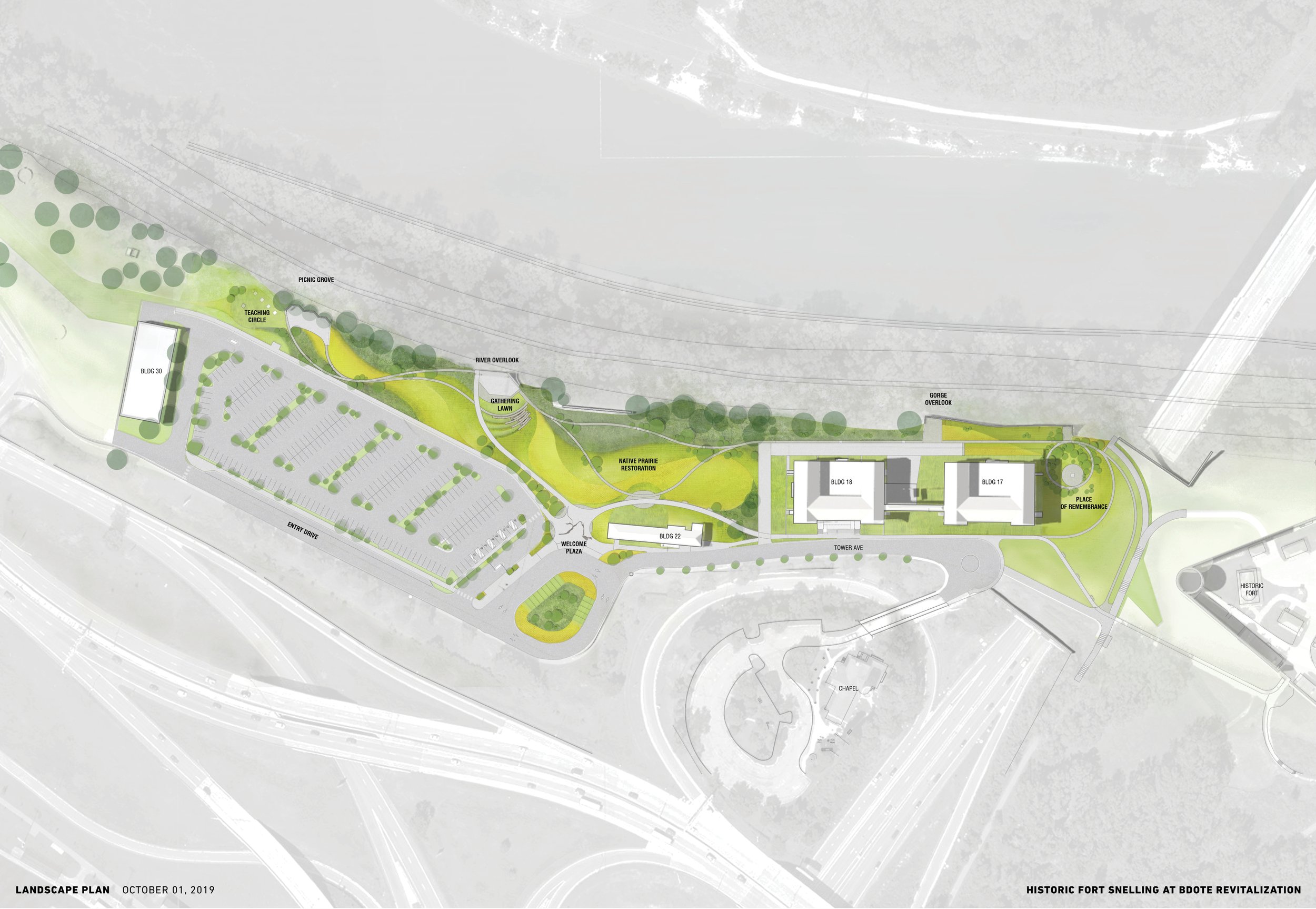
Historic Fort Snelling’s buildings and grounds did not serve the public well. The revitalization project includes the removal of a failing 1980s underground visitor center and creation of the dynamic new Plank Museum & Visitor Center inside a rehabilitated 1904 cavalry barracks. The new year-round visitor center offers exhibit spaces and galleries, meeting rooms and classrooms, plus accessible restrooms, a museum store, and grab-and-go food and beverage.
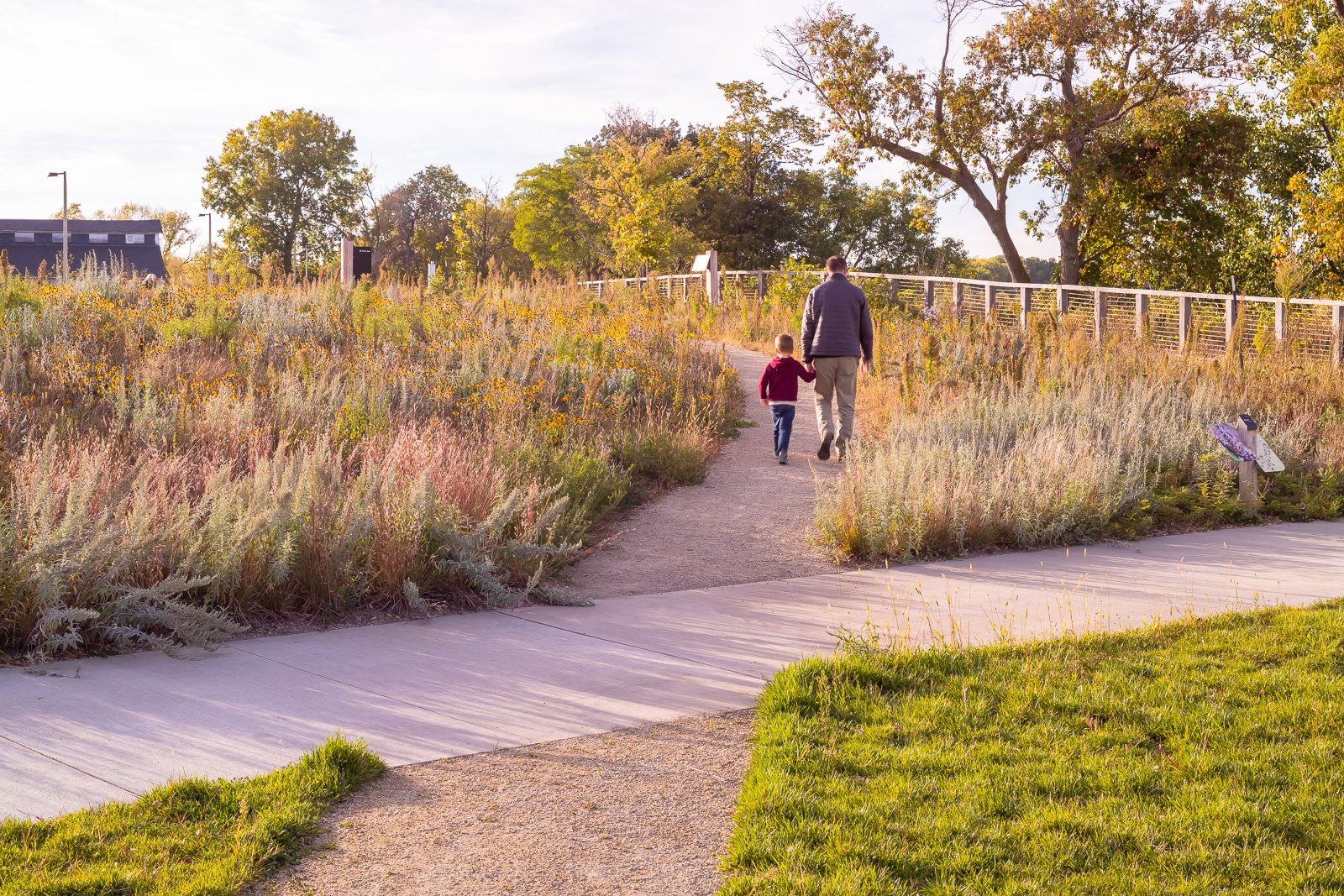
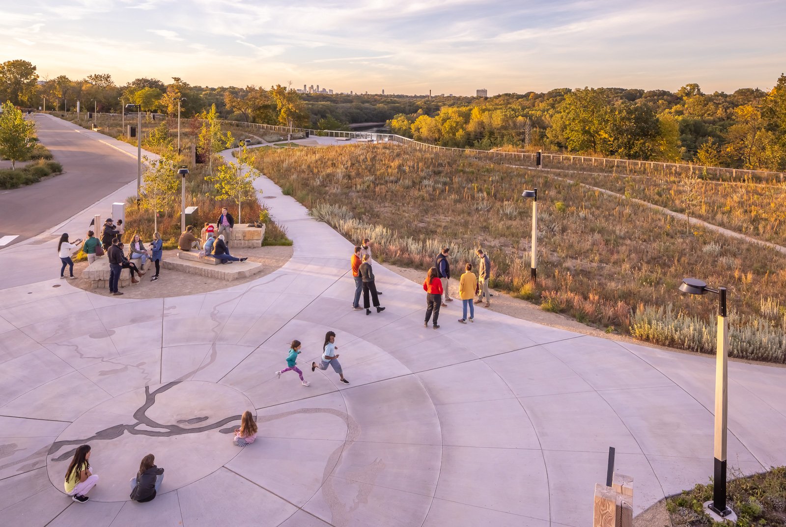
A new comprehensive network of paths weave across the landscape to connect the historic buildings with new gathering spaces and landscape assets (the bluff, the river views, and existing and restored native plant communities) in more intuitive and meaningful ways. A re-configured parking lot and simplified arrival sequence funnels visitors to the Hale Welcome Plaza, where stacked limestone slab outcroppings, wood timber benches, and multi-stem birch groves flank a large open plaza. Here visitors are immediately grounded in the site’s history as Dakota Homeland. The plaza hosts a large bronze river inlay of Bdote to mark the sacredness of the confluence of the Mississippi and Minnesota rivers for Dakota people.
Photo by FARM KID STUDIOS.
Photo by FARM KID STUDIOS.

Photo by FARM KID STUDIOS.
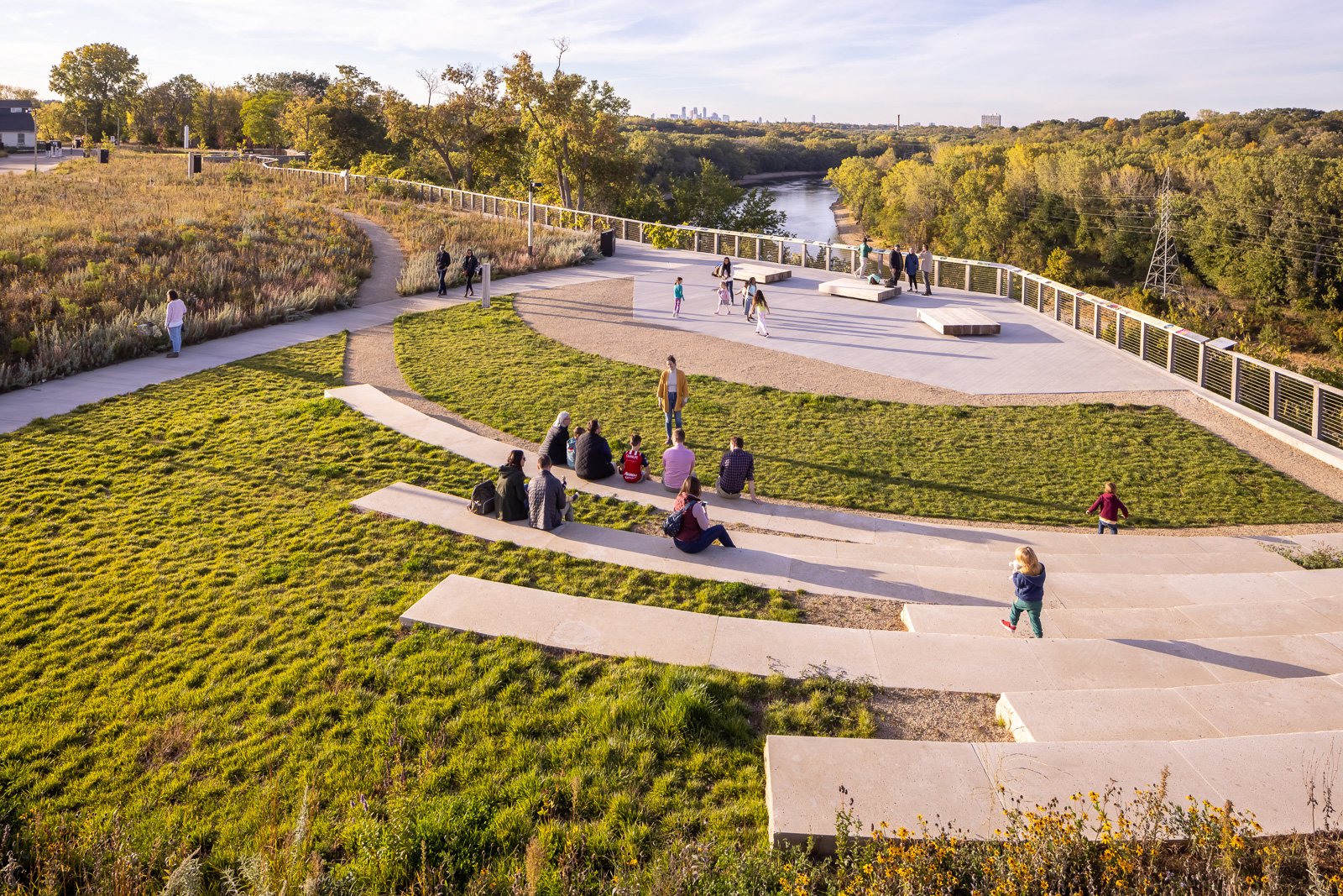
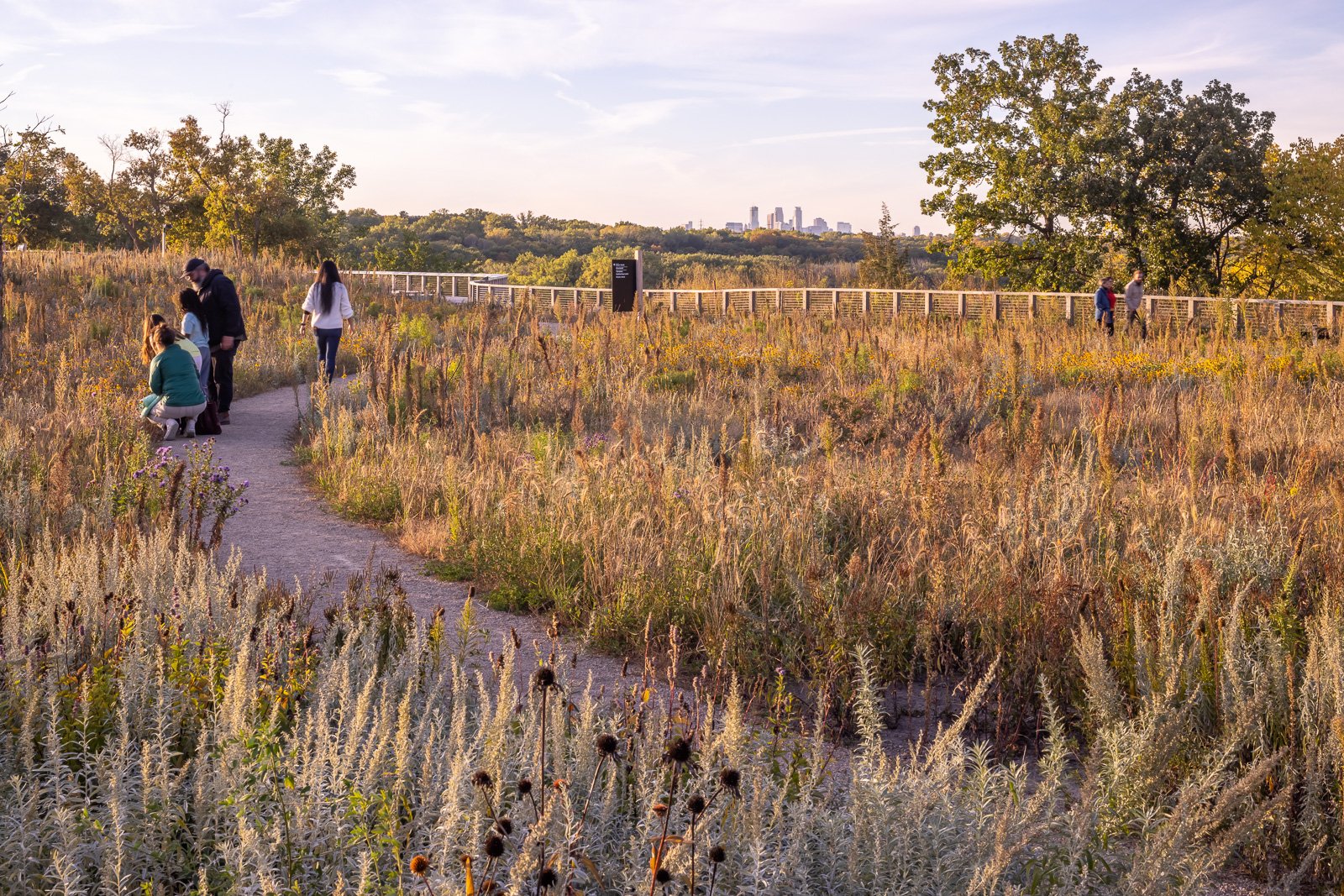
The site continues to welcome people to linger, reflect, celebrate, and contemplate. New overlooks along the Wakpa Tanjka/Mississippi River offer opportunities to view natural and built surroundings. From the Welcome Plaza visitors can move along the primary path to the Plank Museum and Visitor Center or down to the Klas Overlook, which is anchored into the foundations of the former visitor center and cantilevers over the edge of the bluff, providing sweeping views of the Mississippi River and the Minneapolis skyline. The overlook railing is capped by a wide lean bar inlaid with messaging that celebrates a timeline of the site and themes of kinship and Mitakuye Owasin (We are All Related) which honors the interconnectedness of all living beings. From the Klas Overlook, intimate paths through the restored prairie landscape lead small and medium gathering areas and river overlooks along the bluff edge, providing a range of places for groups of different sizes to gather for tours, performances, classes, and individual reflection.

Photo by FARM KID STUDIOS.
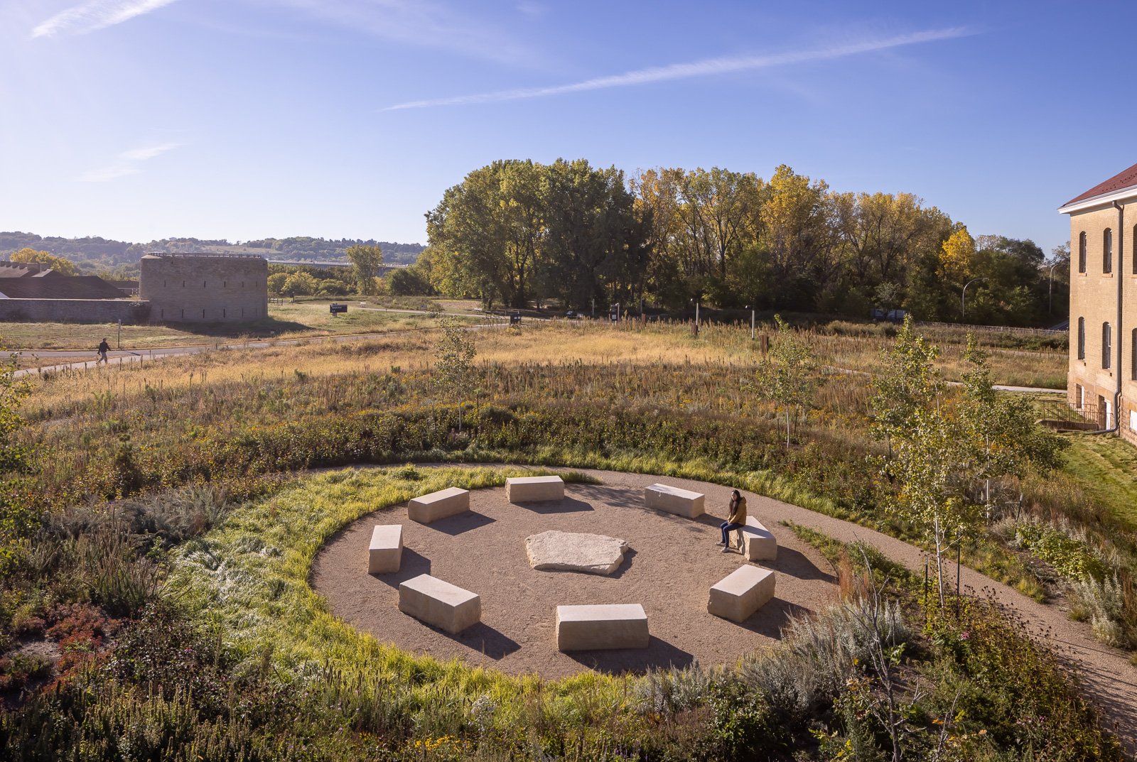
The western end of the site hosts a large teaching lawn, flanked by foraging plants such as chokecherry trees and wild strawberries, a stone fire slab for ceremonies, and picnic tables in a grove of honey locust trees. The eastern end of the project site, before reaching the stone walls of the Historic Fort, is home to the Wokiksuye (Place of Remembrance), a circular memorial space embraced by two arching berms planted with healing and protector plants such as red-twig dogwood, sweetgrass, white sage, echinacea, and white cedars. Limestone benches encircle a stone fire slab in the center of the space. This is the site where two chiefs, Medicine Bottle and Shakpedan, where executed in the aftermath of the US-Dakota War. This space pays tribute to the many lives shaped by this place and the generations who lived, labored, and learned here; to recognize the pain, loss, and sacrifice of those connected to this place; and to honor Minnesota’s shared history, together.
The design team integrated new site new lighting, fences, benches, picnic tables, and signage across the site working with a material palette sensitive to requests from the DCC and the Ina Maka subcommittee to use natural materials such as wood and stone as much as possible. Thermally modified ash, FSC certified black locust, and locally quarried limestone dominate the materiality of the site elements.

Photo by FARM KID STUDIOS.

Photo by FARM KID STUDIOS.

Photos by FARM KID STUDIOS.
Photo by FARM KID STUDIOS.
PRAIRIE RESTORATION + RESILIENCE
One of the most significant contributions to the site’s transformation is the expansive extent of prairie and oak savannah restoration, which is also a significant opportunity to rebuild and reconnect relationships to this place as Dakota homeland. Restored savanna, woodland, prairie, and wet meadow landscapes extend from east to west across the site. Several small lawn areas, paved plaza and gathering areas, and paved pathways exist in order to provide universal access throughout the landscape.
The landscape architects worked to build a resilient plant palette for the prairie restoration using several tools: historic inventories of plants that were catalogued here in the 19th century, culturally significant plant lists from Dakota elders, and climate change research showing how the hardiness zones within the river valley is shifting over time. This carefully curated seed and plug palette was developed specifically for this site to ensure that the plants thrive, help rebuild lost connections to this land, and are resilient long into the future.

WEAVING LANDSCAPE + STORIES TOGETHER
This project presents a difficult and important challenge - how can a restored oak savannah and prairie landscape experienced through new immersive pathways, with new messaging, gathering spaces, and carefully situated river overlooks shift community relationships to this place? The design team worked to reshape the experience of this landscape, drawing from oral history of human movement throughout the river valleys, and create a new system of woven threads of crushed limestone pathways that dance along the bluff edge – moving to the river, into and through the landscape, and back to the river again. Extensive prairie restoration and culturally significant plantings offer an immersive sensory experience that is dynamic across the seasons.
As a symbol of colonialism and destruction for Native culture, it was essential for this landscape to become a space where Dakota and other Native peoples can come to the Fort and feel like it is a place where they belong. Prior to this project commemoration and interpretation focused on stories of westward expansion and military history. The goal for interpretative messaging for Historic Fort Snelling at Bdote is to inspire a better future by providing a place to learn, share and connect to all the complex stories that shape history in Minnesota. With a human history 10,000 years in the making, the area around Fort Snelling is the site of essential stories of our shared past.
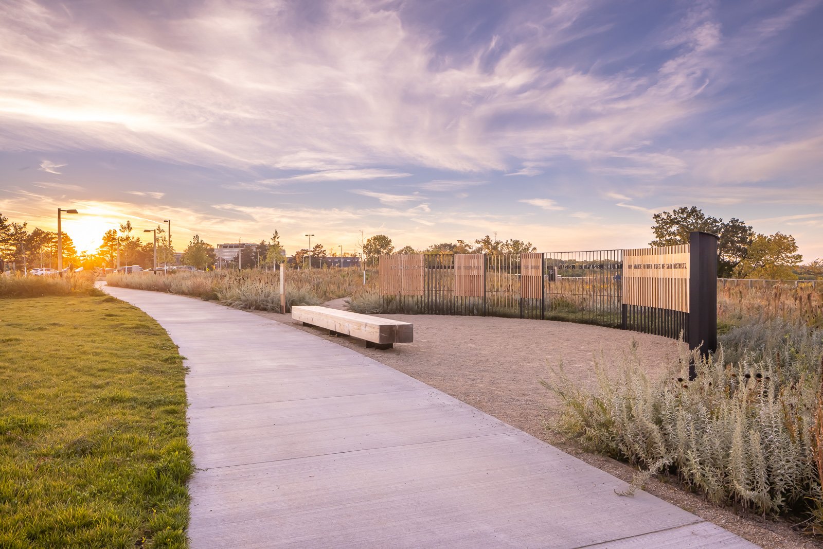
The landscape architects worked with the Ina Maka subcommittee, DCC, and Indigenous artists Erin Genia and Holly Young to incorporate Dakota language, knowledge, and worldviews into the new narratives, images, and design of the messaging features. Through engagement, patience, and collaborative co-development, the new landscape spaces and elements do not hide or ignore the tensions and discomfort that exists here. New narratives provide informed, honest, empathic, and respectful accounts of a difficult past while offering spaces for reflection and healing.
Several interpretive messaging features are integrated into the new landscape:


Photo by FARM KID STUDIOS.
BDOTE PLAZA MAP

Photo by FARM KID STUDIOS.
RIVER OVERLOOK TACTILES

Photo by FARM KID STUDIOS.